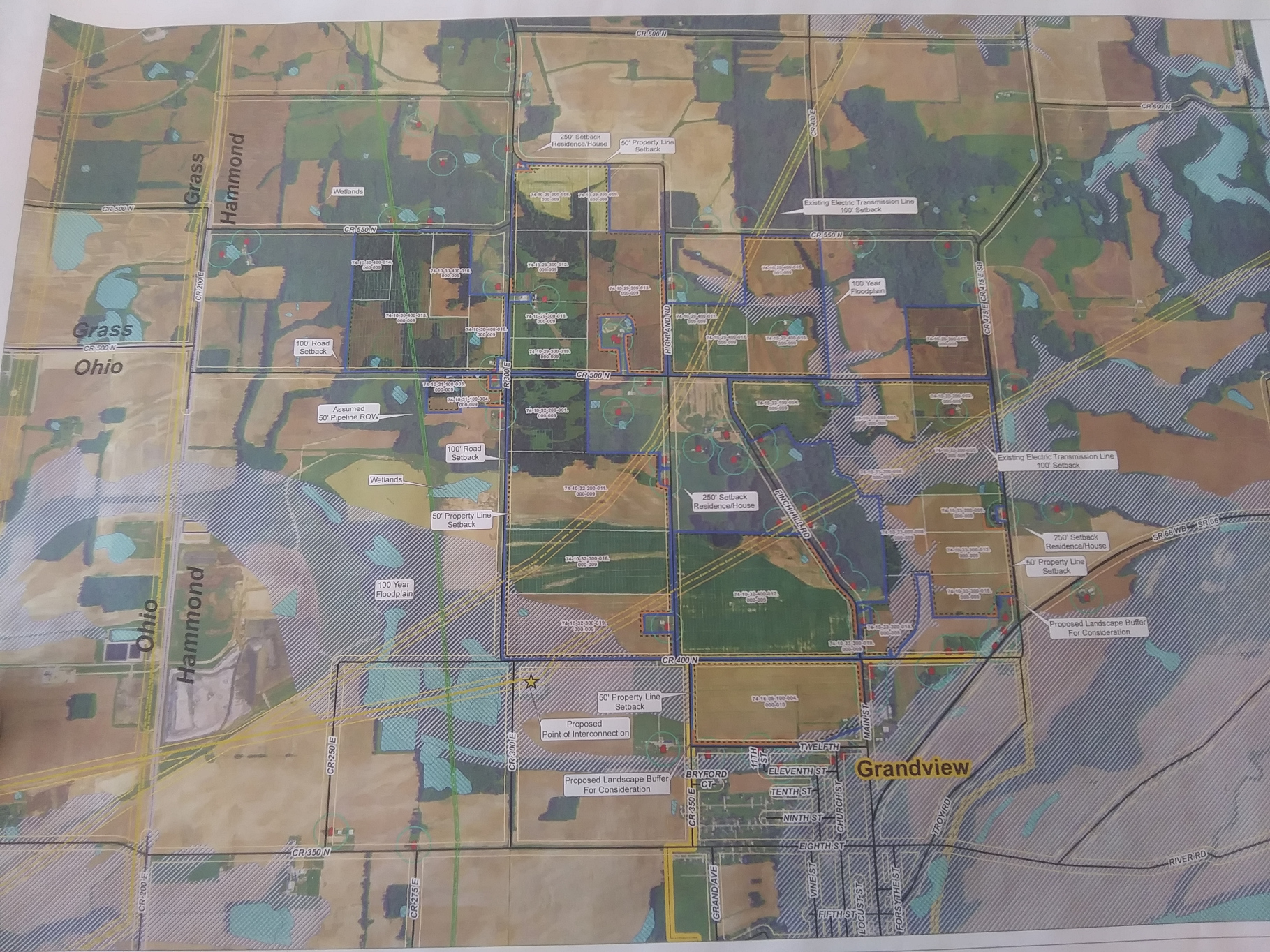
This is a map of the proposed solar farms that will be built outside of Grandview, Indiana.
This project will be leasing at least 30+ parcels of land, mostly farm land that is currently producing crops.
Every parcel of land that has a series of black numbers with a white border around the numbers, is a parcel of land where they want to place solar farms.
The area's containing a series of white lines is marked as part of their floodplain. (This area was covered with a massive flood within the last 100 years and now any mobile homes in that area have to be built on stilts or blocks of a certain elevation.
Grandview Indiana Solar Project Map 1
Dated 9-15-2020
All of the little red squares with a blue circle around them, are buildings. A few of these buildings might be barns, but most of them are homes.
We counted over 50 buildings and know of several that are not even displayed on this map, because they were built AFTER this map was drawn up, due to new property owners not knowing a solar farm would be built next to their new home.
You might also notice that every parcel of land that was voted on by the Town of Grandview, Indiana is outside the city limits except for one parcel on the corner of Twelfth St and Main St. and we counted 10 buildings adjoining just around that one parcel of land.
Most of the land owners that signed leases do not live on the land they are leasing out.
Some final thoughts
The town of Grandview is built right on the banks of the Ohio River and there are drainage ditches on some of these farms that spill into tributes that feed the Ohio river.
Therefore the chances of erosion and top soil being fed into the Ohio river as a result of construction are about 100%. Plus there is another solar farm of over 1,000 acres being built just a few miles away in the same county that also sits right on the banks of the Ohio river.
Also, there is a major coal powered power plant originally built by I&M back in the 1970's against the wishes of many local residents.
That plant sits of over 4,000 acres of land that is located around 3 miles from where some of these new solar farms will be built.
There is talk in the area stating that coal powered plant will be shutting down.
If that is true, why wouldn't the local officials that don't seem to care about their own voters, have the solar farms built on the acreage currently used by AEP, the company that now owns I&M Electric?
And don't tell us the local officials are doing all this to deal with climate change, when they are at the same time, trying to have the only 'Coal to diesel' plant in American, built in this same county.
I don't want to call certain people corrupt or stupid, but there is a lot going on here that doesn't make sense.
If you have trouble seeing this map, you are encouraged to opposite click on the image and SAVE AS an image on your own system so that you can enlarge it.


 This is a map of the proposed solar farms that will be built outside of Grandview, Indiana.


No Comments have been Posted.